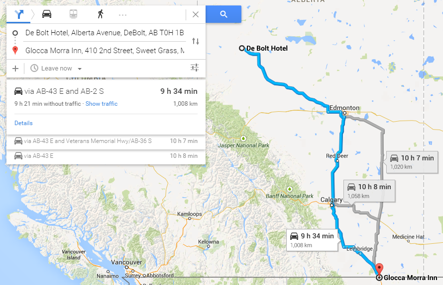
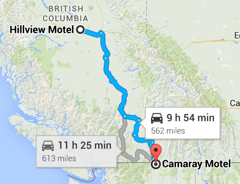
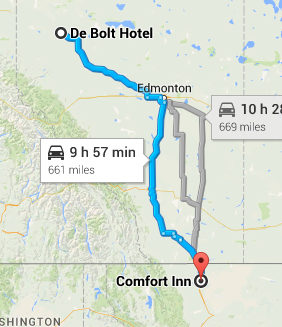
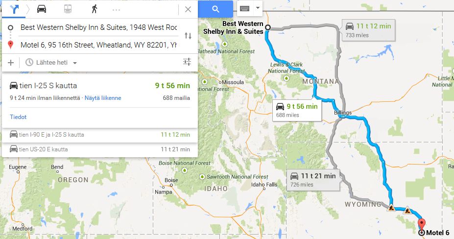
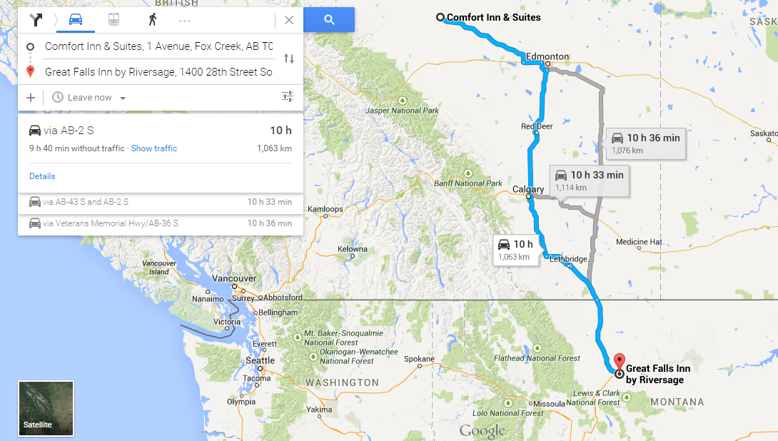
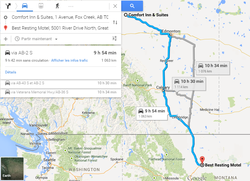
Google Navigation Challenge 2. Prudhoe Bay - Ushuaia

Archive for the three above subforums
User avatar
Samster
Posts: 1658
Joined: 02 Feb 2010, 20:27
Location: Newark, England
Contact:

Re: Google Navigation Challenge 2. Prudhoe Bay - Ushuaia

Post by Samster »

I'd like to enter late if I can, only just saw this. I'll take any penalties you want to give me, I had too much fun with the last one to miss out on this one. :)

Leg 1 Deadhorse to Coldfoot https://www.google.co.uk/maps/dir/Deadh ... !3e0?hl=en
Leg 2 Coldfoot to Tok https://www.google.co.uk/maps/dir/Coldf ... !3e0?hl=en
Leg 3 Tok to Inn on the Lake, Whitehorse https://www.google.co.uk/maps/dir/A+Moo ... !3e0?hl=en
Leg 4 Inn on the Lake, Whitehorse to Toad River Lodge, BC https://www.google.co.uk/maps/dir/Inn+O ... !3e0?hl=en
Leg 5 Toad River Lodge, BC to Grand Prairie https://www.google.co.uk/maps/dir/Toad+ ... !3e0?hl=en
Leg 6 Grand Prairie to Milk River https://www.google.co.uk/maps/dir/Grand ... !3e0?hl=en

This leaves me just outside the lower 48. Was torn between heading towards the I-5 route along the Pacific states or the I-25 route along the Rockies.
User avatar
the Masked Lapwing
Posts: 4204
Joined: 10 Sep 2010, 09:38
Location: Oran Park Raceway

Re: Google Navigation Challenge 2. Prudhoe Bay - Ushuaia

Post by the Masked Lapwing »

Leg 6
Start: De Bolt Hotel, Alberta Avenue, DeBolt, AB T0H 1B0, Canada
Finish: Glocca Morra Inn, 410 2nd Street, Sweet Grass, MT 59484, United States
Distance: 1,008 km (total 4,355 km)
Time: 9 hrs, 34 mins (total 2 days, 7 hrs, 25 mins)

Image

An old and slightly mad Australian man wrote:Today I found a lot of civilization.
I miss Alaska now.
I've made it to the US proper, which means a few days of awfulness. Fortunately, I've got a route that makes a lot of use of the interstates, so it shouldn't be too long before Mexico.
So far, only one other team has finished with me, but every time I mention potential privacy half the goddamn race shows up, so I'm not going to.
R.I.P.
GM HOLDEN
1948-2017
User avatar
UncreativeUsername37
Posts: 3420
Joined: 25 May 2012, 14:36
Location: Earth

Re: Google Navigation Challenge 2. Prudhoe Bay - Ushuaia

Post by UncreativeUsername37 »

I got way too excited when I saw the time
Start: Holiday Inn Hotel & Suites Grande Prairie-Conference Ctr, 9816 107 Street, Grande Prairie, AB T8V 8E7, Canada
Finish: Prairie Rose Lodge, 117 3 Avenue Northwest, Milk River, AB T0K 1M0, Canada
Rob Dylan wrote:Mercedes paying homage to the other W12 chassis by breaking down 30 minutes in
User avatar
Peteroli34
Posts: 1957
Joined: 25 May 2013, 10:01
Location: Thurrock, Which isn't London

Re: Google Navigation Challenge 2. Prudhoe Bay - Ushuaia

Post by Peteroli34 »

Day 6

Start: Hillview Motel, 1533 16 HWY E, Vanderhoof, BC, Canada
Finish: Camaray Motel, Main Street, Oroville, WA, United States
Distance Traveled: 562 Miles
Time Traveled: 9h 54M
Total Distance:2589 Miles
Total Time: 55h 28M


Image

Day 6 saw us out on our own for the first time, we entered to the town of Prince George today the largest settlement we have seen since we started we continued travelling south towards the border with the United States. Was given a few funny looks by the border agent, yes officer that is me the picture just 4 years old. Anyway despite being held up at the border we had entered the Contiguous United States, Washington to be precise with time running out we found a Motel a few miles from the border to stay in. It seems those Canadian kids who for some reason I thought were Australian were also here
User avatar
WaffleCat
Posts: 2293
Joined: 08 Jan 2012, 13:02
Location: Singapore

Re: Google Navigation Challenge 2. Prudhoe Bay - Ushuaia

Post by WaffleCat »

LEG 5

Start: Folding Mountain Bed & Breakfast, Alaska Highway, Toad River, BC, Canada
End: De Bolt Hotel, Alberta Avenue, DeBolt, AB, Canada
Leg Time: 9h 33 mins
TOTAL TIME: 1 day, 21 hours, 49 mins

Today, Mike was actually competent. Maybe it was the coffee. Or the alarm clock. Or whatever he did last night. Whatever it was, he was extra sprightly and actually wanted to press on with the challenge. And then we heard someone blast their horn as they flew past. That seemed to ignite a fierce fighting spirit I've never seen before in Mike. It was like he was ready to unleash something I've never seen before

5 minutes later, he threw up.

I had never seen Mike throw up until then.

And Mike returned back to his good old self.

And since he elected to drive the whole way while in his adventurous spirit, Mike elected to simply follow the Belgians. Made for an absolutely boring trip. Apart from the time where we blasted past the horny team that ignited Mike's breakfast earlier. Mike could not help but sound his horn back as we sailed right by.

And he threw up again.

Mike must be allergic to car horns. Reminder to prescribe medication next leg.

-----------------------------------------
Leg 6

DeBolt Hotel

We set off a little later than normal. Mike was still cleaning up some of his sick off the car from yesterday and I wanted to consult a map. We'd make it to Montana, that's for sure. Mike can imagine what it would be like to live in a city for once on this trip at Edmonton and Calgary, but we're going to motels buddy, so suck it up.

We were starting to enter civilisation.

Edmonton

Mike stopped here for pancakes. Says it couldn't be more authentic than this.

He got it from a bloody McDonalds.

I look at Mike.

Mike shuts up.

Thank god.

US Border

Mike was supposed to take over driving from here. Mike was supposed to deal with security. Mike was supposed to top the car up with gas from here as well.

But Mike is now asleep. And security is now questioning me what I'm hiding in all the bloody large bags Mike brought along for the trip, and also questioning the unconscious body next to me with an unfinished breakfast still in the car.

Good luck, me.

Browning

I DID NOT WANT TO GO HERE. BLOODY INDIANS. NICOLAS SAID WE COULDN'T MAKE IT TO SHELBY OR CUT BANK. I CALL BULLSHITE. WE MISSED THE GLORIOUS INTERSTATE. NOW THERE'S INDIANS HERE AND THE TOWN LOOKS CREEPY. WE COULD HAVE STAYED IN A HOLIDAY INN NEXT TO A MUSEUM AND INSTEAD WE ARE STUCK IN A MOTEL NEXT TO AN ABANDONED PETROL KIOSK. GET ME OUT OF THIS PLACE. IT STINKS LIKE A MOTHERFU

Sorry. Mike took over the keyboard. Lovely place here. Million times better than Coldfoot, trillion better than the Arctic Circ

ARCTIC CIRCLE WAS BETTER THAN THIS SHI

Yeah, Mike took over the keyboard again. Once again, lovely place. Brilliant food. I might visit this place again just for a short holiday.

HOLIDAY? MORE LIKE A TASTE OF HELL.

Mike couldn't be any happier right now, given that he's fallen asleep.

Involuntarily.
----------------------------------------
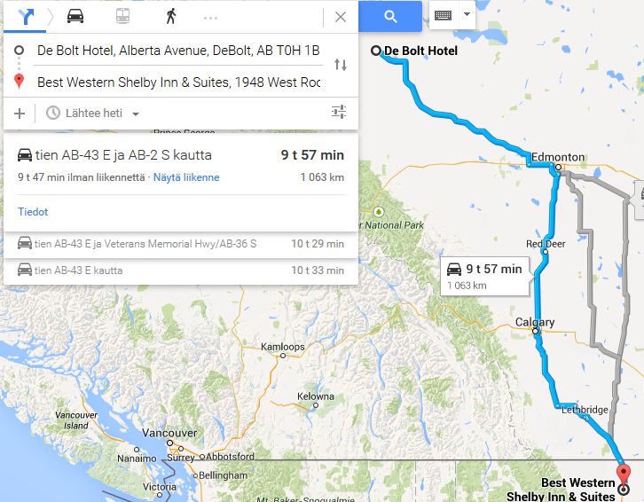
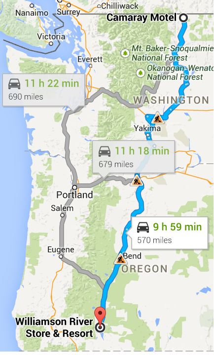
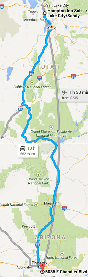
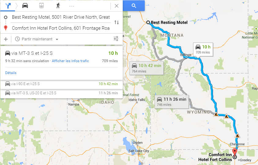
Start: De Bolt Hotel, Alberta Avenue, DeBolt, AB, Canada
End: Western Motel, 121 Central Avenue, Browning, MT, United States
Leg time: 9 h 41 mins
TOTAL TIME: 2 days, 7 hours, 30 minutes
My friend's USB drive spoiled, spilled tea on her laptop and had a bird poo in her hand.

What did she do in her past life to deserve this?

Signup for the Random Racing League, Season TWO!!!
User avatar
DemocalypseNow
Posts: 13185
Joined: 17 Aug 2009, 09:30
Location: Lost, send help
Contact:

Re: Google Navigation Challenge 2. Prudhoe Bay - Ushuaia

Post by DemocalypseNow »

Jeremy-Etienne Voeckler wrote:Aha! Look at zem! Zey are lost! I can see Yael squinting at ze map! Now Freddy, attaque!!!!!

Frederic-Maxime Voeckler wrote:Non non non...I tell you so many times, this is endurance, not a sprint. If you rush me I will take a wrong turn and we will end up in Newfoundland or something!!!


So, for a second day, ourselves and De Bocks set off from the same place, at roughly the same time. I got distracted by the croissants the hotel offered with the complimentary breakfast and thus Team Voeckler set off a couple minutes after the Belgian duo.

Things got interesting as we got towards Edmonton - on the outskirts of the city, JE noticed just ahead that the De Bocks had taken a different turn-off to ours. Surely they aren't heading to Saskatchewan, are they!? That's kind of what it looked like...

Regardless, we pushed on, heading Due South, beyond Calgary and towards the United States border. Border control didn't hold us up for long at all thankfully - I think they just assumed from the accents that we were French Canadians or something, eh?

After the long jaunt through Canada, we were back in US territory. Winding our way down I-15, we reached Great Falls, with only a few minutes left on the clock. When JE noticed that Vegas was on the I-15, he became a bit single-minded, and took offence to me turning into Great Falls town itself, off the interstate. But we had to, it looked like all the hotels were in the middle of town. We found a place just in the nick of time, Great Falls Inn. Sounds straightforward and homely, but apparently it's part of a chain or something.

The two of us are split on where to go next. JE being JE, wants to go to Vegas and party. But that isn't exactly the fastest way to get to Mexico. We'll see if we can finally decide what to do after dinner. And it looks like we might be alone this time. Maybe those crazy Belgians did go through Saskatchewan after all.

Team Voeckler's Leg Six Road Map
Novitopoli wrote:Everytime someone orders at Pizza Hut, an Italian dies.
Novitopoli wrote:Juve's Triplete: Calciopoli, doping & Mafia connections.

Image Image
User avatar
Nuppiz
Site Donor
Site Donor
Posts: 5942
Joined: 30 Mar 2009, 12:10
Location: Vantaa, Finland
Contact:

Re: Google Navigation Challenge 2. Prudhoe Bay - Ushuaia

Post by Nuppiz »

Leg 6
Start: De Bolt Hotel, Alberta Avenue, DeBolt, AB T0H 1B0, Canada
Finish: Best Western Shelby Inn & Suites, 1948 West Roosevelt Highway, Shelby, MT 59474, United States
Distance: 1063 kilometres (661 miles)
Time: 9 hrs 57 mins

Total distance: 4411 kilometres (2741 miles)

Image

Nathan Nurmester wrote:Day 6. We bolted off from De Bolt early in the morning, knowing that today we'd have to get across the border to USA again if we wanted to retain any chance at being near the top of this rally. With about half an hour to spare we managed that, and instead of staying in the border town of Sweet Grass we decided to push further on the I-15. We managed to get to town called Shelby - fitting name for a location along a rally route - with minutes to spare and got into a luxurious hotel (at least compared to our previous lodgings) right next to the Interstate highway, allowing us to continue our travel at maximum speed tomorrow.
Eurosport broadcast for the 1990 Mexican GP prequalifying:
"The Life, it looked very lifeless yet again... in fact Bruno did one, slow lap"
User avatar
Shadaza
Posts: 2775
Joined: 05 Jun 2009, 23:49

Re: Google Navigation Challenge 2. Prudhoe Bay - Ushuaia

Post by Shadaza »

Start: De Bolt Hotel, Debolt, Grand Prarie
Finish: Comfort Inn, Shelby, Montana

Image

Smooth sailing through Edmonton, but there was a little bit of traffic at the Canadian border.

Yeehaw, back in the states. Stopping off at Shelby and finding yet again my car is not the only one here. At least we save a couple of quid on the hotel room over the Fins.
Message me on Discord.
User avatar
tommykl
Posts: 7078
Joined: 07 Apr 2010, 17:10
Location: Banbury, Oxfordshire, UK

Re: Google Navigation Challenge 2. Prudhoe Bay - Ushuaia

Post by tommykl »

Thomas De Bock wrote:Prudhoe Bay - Ushuaia Challenge - day 5: Fox Creek to Great Falls

The Voecklers were quite animated at breakfast again. Slightly miffed at ending up at the same place we had, they were planning every step to get the edge. So were we. Perhaps this time, we'd end up in slightly different places. Or, more interestingly, vastly different places. They got caught up early on and left a couple of minutes behind us, and we naturally headed towards Edmonton. While the settlements were definitely more frequent, there still wasn't much scenery to speak of. Soon, Highway 32 branched off to the North and Swan Hills. We passed Whitecourt, Mayerthorpe, Rochfort Bridge, Sangudo, Cherhill, Yellowstone (Wyoming? Already?), Gunn, and then finally, we reached the first national highway of the whole journey.

Alberta Highway 16 was the Yellowhead branch of the Trans-Canada Highway, and would take us towards Edmonton even faster. Along the highway, we finally had no gaps. Regular exits and regular sights of houses. Plenty of cars on the road to keep us company...and hold us up. We took a lead over the Voecklers through the traffic and never saw them again. The map told us they were around 5 minutes behind the whole way. Then, suddenly, in the distance, there it was. The first true metropolis of the journey. Edmonton. We desperately wanted to enter and enjoy all the things a big city has to offer. We couldn't. We'd lose too much time.

Hopefully, we'd have been in a reasonably large place at the end though. In the meantime, we headed South around the ring road, then South for good. After the suburb of Nisku, we definitively left Edmonton and headed towards Calgary. Monotony returned after its area of influence waned. Then, they started appearing again. Soon enough, we'd reached Red Deer. A couple of hours later, Calgary came into view. Unlike Edmonton, Calgary's ring road wouldn't help, so we drove straight through the centre, though still on the highway. The temptation to stop was ever higher, but we resisted. We'd reached the halfway mark.

Small towns got ever more present, and when we reached Granum, we turned East just short of Fort McLeod, briefly took Highway 519, then Highways 23 and 3, through Lethbridge and finally towards the Continental United States. Y'all started to tire, so I took the wheel and continued towards the border on Highway 4. We were expecting most teams to stop there or just South of the border. We'd head further South, presumably the Voecklers too.

Albert Provincial Highway 4 was now the I-15. After the green plains of Alberta, everything was suddenly a lot browner. Then it hit me. Corn fields. Corn fields everywhere. What was this, Nebraska? Aside from the odd corner, the road itself wasn't very interes-HEY! Y'ALL! WAKE UP, we're almost there! Time went by so slowly that we thought we'd never get there. The neverending stream of country music on the radio didn't help. When we finally reached the city of Great Falls, Montana, we barely had time to think. We left the I-15, but crucially, not at the main exit.

You see, we'd planned ahead. Looking at accommodation in Great Falls, we found we could afford to go as far as we wanted. We went for the one that was closest to the road out of the city. This ivolved finally going into a city centre. For the very first time on the trip. We never thought the adrenaline would pump quite this fast for something this mundane, but when we crossed the Missouri river and got stuck in traffic, there it was. The buzz. We couldn't quite understand why we were happy to be stuck in traffic. and yet we were. We drove alongside the river, then finally reached our spot for the night. The Best Resting Motel.

Finally. 'Murica. Three days and we'd be out of there, we thought. Oh well. Time to actually go out and do things. We hadn't done that in a week, things...


http://www.formularejects.com/uploader/ ... e/leg6.png

Staying at the Best Resting Motel, 5001 River Drive North, Great Falls, MT 59405, USA

Route details: 1 Ave, Fox Creek - River Drive North, Great Falls.

2 days 8 hours 46 minutes total driving time
4527 kilometres total distance
kevinbotz wrote:Cantonese is a completely nonsensical f*cking alien language masquerading as some grossly bastardised form of Chinese

Gonzo wrote:Wasn't there some sort of communisim in the East part of Germany?
User avatar
Shadaza
Posts: 2775
Joined: 05 Jun 2009, 23:49

Re: Google Navigation Challenge 2. Prudhoe Bay - Ushuaia

Post by Shadaza »

Samster wrote:I'd like to enter late if I can, only just saw this. I'll take any penalties you want to give me, I had too much fun with the last one to miss out on this one. :)

Leg 1 Deadhorse to Coldfoot https://www.google.co.uk/maps/dir/Deadh ... !3e0?hl=en
Leg 2 Coldfoot to Tok https://www.google.co.uk/maps/dir/Coldf ... !3e0?hl=en
Leg 3 Tok to Inn on the Lake, Whitehorse https://www.google.co.uk/maps/dir/A+Moo ... !3e0?hl=en
Leg 4 Inn on the Lake, Whitehorse to Toad River Lodge, BC https://www.google.co.uk/maps/dir/Inn+O ... !3e0?hl=en
Leg 5 Toad River Lodge, BC to Grand Prairie https://www.google.co.uk/maps/dir/Toad+ ... !3e0?hl=en
Leg 6 Grand Prairie to Milk River https://www.google.co.uk/maps/dir/Grand ... !3e0?hl=en

This leaves me just outside the lower 48. Was torn between heading towards the I-5 route along the Pacific states or the I-25 route along the Rockies.


Whilst I do welcome the entry, your legs don't end at specific hotels or rest stops which are needed for this race (yes that wasn't the case last time.) Regardless I will put you in the game and on the map, just try and do this from now on.
Message me on Discord.
User avatar
Shadaza
Posts: 2775
Joined: 05 Jun 2009, 23:49

Re: Google Navigation Challenge 2. Prudhoe Bay - Ushuaia

Post by Shadaza »

https://www.google.com/maps/d/edit?mid= ... ues3h3pOJ0

I can't offer more than the map today, really.

Teams are back in the US or very nearly back in the US. With Samster joing the race late adding a growing list.

Leg 7 is now open. I apologise for being brief tonight.
Message me on Discord.
User avatar
Bobby Doorknobs
Posts: 4059
Joined: 30 Jul 2014, 17:52
Location: In a safe place.

Re: Google Navigation Challenge 2. Prudhoe Bay - Ushuaia

Post by Bobby Doorknobs »

EDIT: Google Maps is now informing me that the Motel 6 I originally intended to stop at is closed. Accommodations have been changed accordingly.

Day 7

Start: Glocca Morra Inn, 410 2nd Street, Sweet Grass, MT 59484, United States
Finish: Rustic Inn Curio Shoppe, 701 East Richards Street, Douglas, WY 82633, United States
Distance Traveled: 664 miles
Time Traveled: 9h 58m
Total Distance: 3,364 miles
Total Time: 2d 17h
Anthony Byrne wrote:And so concludes the first week of our trans-continental journey. We've made it about halfway across North America now. Last night our company consisted of the Australian man from Toad River. We could have sworn he was one of the crowd that went in the direction of DeBolt. Maybe he made the same mistake we did (well, Eoin did) when we stopped at Grande Prairie? It doesn't matter anyway. We crossed the entire state of Montana today. It really is a beautiful place. We also made it halfway across Wyoming and again we were cutting it close. This time we were two minutes away from the maximum time as we pulled into the city of Douglas. We may not have the best car, and we may be two hours behind the De Bocks and the Voecklers, but that makes us no less determined to win this thing.
Last edited by Bobby Doorknobs on 17 Apr 2015, 00:38, edited 2 times in total.
#FreeGonzo
User avatar
Samster
Posts: 1658
Joined: 02 Feb 2010, 20:27
Location: Newark, England
Contact:

Re: Google Navigation Challenge 2. Prudhoe Bay - Ushuaia

Post by Samster »

Leg 7 Milk River, AB to Glenrock, WY https://www.google.co.uk/maps/dir/Milk+ ... 1534?hl=en

Leg 7 takes us back into the US for our first of what we hope will be no more than three days in the lower 48. With the glorious Interstate network beckoning we crossed the border and sped down I-15 till Great Falls where we would take a shortcut to Billings using the old US roads. With half of our time still remaining we pressed on south on I-90 then I-25 towards Denver achieving our target of making it into Wyoming. Just past Capser (the friendly ghost town) we turned off the Interstate to find the small town of Glenrock and the Higgins Hotel will be our rest-stop for the night.
User avatar
V8fan12
Posts: 1167
Joined: 26 Nov 2013, 21:39
Location: The Dotcom Mansion, New Zealand

Re: Google Navigation Challenge 2. Prudhoe Bay - Ushuaia

Post by V8fan12 »

Day 7

Start: Camaray Motel, 1320 Main Street, Oroville, WA 98844, United States
Finish: Lonesome Duck Ranch, 32955 Hwy 97 North, Chiloquin, OR
Distance Traveled: 568 miles
Time Traveled: 9h 54min
Total Distance: 5124 km / 3184 miles
Total Time: 65h 13m

Image
Owner of the Peak Motorsport Group.

Biscione wrote:I mean, Renaldo Jimenez, could you ask for a more world class pay driver? Who even is Alexey Buyvolov, amirite?
User avatar
UncreativeUsername37
Posts: 3420
Joined: 25 May 2012, 14:36
Location: Earth

Re: Google Navigation Challenge 2. Prudhoe Bay - Ushuaia

Post by UncreativeUsername37 »

Route
Start: Prairie Rose Lodge, 117 3 Avenue Northwest, Milk River, AB T0K 1M0, Canada
Finish: Hampton Inn Salt Lake City/Sandy, 10690 Holiday Park Drive, Sandy, UT 84070
Rob Dylan wrote:Mercedes paying homage to the other W12 chassis by breaking down 30 minutes in
User avatar
the Masked Lapwing
Posts: 4204
Joined: 10 Sep 2010, 09:38
Location: Oran Park Raceway

Re: Google Navigation Challenge 2. Prudhoe Bay - Ushuaia

Post by the Masked Lapwing »

Leg 7
Start: Glocca Morra Inn, 410 2nd Street, Sweet Grass, MT 59484, United States
Finish: Super 8 Lehi, 125 South 850 East, Lehi, UT 84043, United States
Distance: 1,147km (total 5,502km)
Time: 9 hrs, 58 mins (total 2 days, 17 hrs, 23 mins)

Image

An old and slightly mad Australian man wrote:My choice to stop just on the American side of the border rather than continue on has paid off. No one else joined me, and I was free to continue down my route of choice.
My route is now interesting. I plan on taking a straight route south through the US, before turning east in Mexico. I'll lose time this way, but I can make it up later.
Maybe.
At the very least, until I hit Mexico I won't have to see anyone else.
R.I.P.
GM HOLDEN
1948-2017
User avatar
Nessafox
Site Donor
Site Donor
Posts: 6242
Joined: 30 Nov 2009, 19:45
Location: Stupid, sexy Flanders.

Re: Google Navigation Challenge 2. Prudhoe Bay - Ushuaia

Post by Nessafox »

Leg 7:
Had a good rest. The Native American people weren't so bad. When leaving in the morning, it turned out we weren't the only team in this village. It was the team we'd most wanted to avoid.
It seems the US of A didn't bring much change. Along the road there wasn't a living soul to be seen for miles. The first city of significance we passed was Helena. Not long after that, we encountered some road works in Butte. But after that, it was still the same until we reached Idaho Falls, in the state of Idaho. Again construction work slowing us down in Pocatello. We then entered the state of Utah, and there were more and more towns now. We were closing in on the surroundings of Salt Lake City. Passing the city of Logan reminded us of the fact that we were driving a Dacia, which so far ran surprisingly well. Only a few minor problems like a malfunctioning radio. Well, we had some spare budget so we quicly bought a new one in Salt Lake City. The Great Salt Lake reminds me of how much i miss Belgian Frites (because i put a lot of salt on them) Steph often jokes that i always order salt with frites. At least i'm not a mayonaise addict like her!
Some way south of Salt Lake city, again construction work! We reached the hotel we planned to reach only just in time. It was adviced to us by the people back in Browning. It was pleasing to be welcomed. Maybe we'll check in to one of these Holiday Inn hotels later! American Fork is a funny name though. I'm getting hungry!
Yeah, so far Utah is my favourite place.


Start: Holiday Inn Express & Suites Browning, 50 Museum Loop, Browning, MT 59417, Verenigde Staten
Finish: Holiday Inn Express & Suites American Fork- North Provo, 712 South Utah Valley Drive, American Fork, UT 84003, Verenigde Staten
Distance Traveled: 685 miles
Time Traveled : 9h 59m
Total Distance: 1802 Miles + 2561 km
Total Time: 65h 26m

Image
I don't know what i want and i want it now!
User avatar
HawkAussie
Posts: 1110
Joined: 21 Nov 2012, 04:59
Location: Tasmania

Re: Google Navigation Challenge 2. Prudhoe Bay - Ushuaia

Post by HawkAussie »

Day 7: Sandman Hotel Grande Prairie, 9805 100 Street, Grande Prairie, AB T8V 6X3, Canada to The Hotel / Club Elevate, 155 West 200 South, Salt Lake City, UT 84101, United States
Total Distance: 5373 kilometres
Total Time: 64 hours and 4 minutes

Finally we have hit the first major city of the USA with us heading to Salt Lake City and we quickly moved off the main highway as their was a crash in at Farmington. But with the route that we are taking, I think we can get to Mexico in about two days and to get to Panama in about eight. That is if we counter any problems.
Officially Retired
User avatar
Peteroli34
Posts: 1957
Joined: 25 May 2013, 10:01
Location: Thurrock, Which isn't London

Re: Google Navigation Challenge 2. Prudhoe Bay - Ushuaia

Post by Peteroli34 »

Day 7

Start: Camaray Motel, Main Street, Oroville, WA, United States
Finish: Williamson River Store & Resort, Modoc Point Road, Chiloquin, OR, United States
Distance Traveled: 570 Miles
Time Traveled: 9h 59M
Total Distance:3159 Miles
Total Time: 65h 27M

Image

A week ago we left Deadhorse now some 2000 miles south we are travelling through Washington state towards Oregon. Progress is good as skirt the national forests that litter this area. Good that is until we near Yakima when we hit the first bit of major traffic since starting. Road works it was It was bound to happen as we headed south bigger towns more traffic but damn its annoying do after we have gone. We hit 2 more pieces of roadworks slowing our progress we begin to find some accommodation finding somewhere overlooking a river but would we make it and we did just about with so many seconds to spare i swear this race is going to give me a heart attack.
User avatar
DemocalypseNow
Posts: 13185
Joined: 17 Aug 2009, 09:30
Location: Lost, send help
Contact:

Re: Google Navigation Challenge 2. Prudhoe Bay - Ushuaia

Post by DemocalypseNow »

Jeremy-Etienne Voeckler wrote:Whoooooooooooooooo are you, who who, who who, whooooooooooooooooo are you, who who, who who, I really wanna knooooooooooow, whoooooooo are you, ooooooooooohhhhhhhhhhhhhhhh, come on, tell me who are you, you, you, aaaaaawwwwwwwww youuuuuu.
Frederic-Maxime Voeckler wrote:I'm the guy that's gonna put your head through the windshield if you don't shut up about Vegas!!!!


Jeremy-Etienne Voeckler wrote:Freddy was really quite angry when he found out the hotel didn't have any Croissants. I had to restrain him. Hopefully we don't need to visit another motel from the same chain, else we might not be welcome anymore!

I really wanted to visit Vegas and have some fun. Who cares if we don't win, I won enough in my career, I don't need another trophy! I just want to relax and have a ball in the city of sin. I ain't gettin' any younger after all, I was hoping this would turn out like Last Vegas II. But no, Freddy is taking this thing super serious.
Frederic-Maxime Voeckler wrote:Anyway, I did seriously consider heading down the I-15 some more towards Salt Lake City. It was a fair few kilometres further to go via Idaho and Utah, but we heard the traffic wasn't so bad compared to taking the I-25 through Wyoming, which was backed up with roadworks. But, this early in the contest, it didn't seem worth taking a risk, and we already knew the De Bocks were planning to head towards Denver anyway, so we figured we'd see if we could find a small edge somewhere over them on the way there.

We were hoping at least to make it to the northern suburbs of Denver, but the traffic through Wyoming was just too heavy and we couldn't make it. We seriously considered playing it safe and pulling over in Cheyenne, the last outpost of civilisation before reaching Colorado, but we risked it. In fact, we came agonisingly close to racking up a time penalty. But, with seconds left on the clock, we reached the main intersection of I-25 and Fort Collins, which had an abundance of hotels and motels. But only literally seconds left on the clock, we had to pull into the closest one to the Interstate exit, rather than pick and choose the best hotel at the intersection (there must have been at least ten!). Thus, we settle down in Comfort Inn, which was pretty decent the last time we stopped at one a few days ago.

We haven't seen the De Bocks for 36 hours now, but I get the feeling they're still no more than a kilometre or two away. Maybe less...JEV, go take a look round the neighbouring hotels. They're surely close, maybe they're even our neighbours again...


Voeckler's Leg 7.
Novitopoli wrote:Everytime someone orders at Pizza Hut, an Italian dies.
Novitopoli wrote:Juve's Triplete: Calciopoli, doping & Mafia connections.

Image Image
User avatar
tommykl
Posts: 7078
Joined: 07 Apr 2010, 17:10
Location: Banbury, Oxfordshire, UK

Re: Google Navigation Challenge 2. Prudhoe Bay - Ushuaia

Post by tommykl »

Thomas De Bock wrote:Prudhoe Bay - Ushuaia Challenge - day 7: Great Falls to Fort Collins

We knew the Voecklers were close behind, but today, we had the opportunity to pull ahead that little bit more. We left Great Falls and headed South East on State Highway 87. After a few miles, we turned straight East on Highway 3. We passed Stanford, then got a bit of traffic turning onto Highway 191. Then a bit more turning onto Highway 12. We weren't actually on the Interstate, which made the road slower, but we thought it would be faster on the way to Panama. We then turned South again on Highway 3 through Lavina.

We continued on our way South, passing small settlements regularly, then reaching Billings, Montana. We crossed the Yellowstone River in the city centre, briefly joined the I-90...then left it to take Highway 87. We turned South after Hardin, and there we were. Wyoming. The Land of the Great Nothingness. The US State equivalent of Deep Blue Something. At some point, the I-90 merged into the highway, though we were so mind-numbingly bored that we didn't really notice.

We passed Sheridan and Buffalo before taking the I-25, due South. Or at least, for a few minutes. It jerked East in the centre of Casper, then South again. A couple of hours later, we were in Cheyenne. We collectively wondered where the Stargate could be found. The fact that we even considered this at all just showed how bored and lonely we were. But it was a wake-up call. Cheyenne meant we were almost upon our destination. Soon thereafter, we reached Colorado.

Our planned stop was in Wellington, the first settlement of relevance on the way. But just as I was turning off the Interstate, Y'all suddenly checked the clock: "CONTINUE! ON A LE TEMPS!" Indeed, we had an extra 7 minutes. This close to Denver, he'd assumed we had enough time to find a hotel that little bit further down the road. We dared to go another exit down the road. Then, with two minutes left, we spotted an ad for some hotels at the next exit. We rushed there and got there with just seconds to spare. We breathed a sigh of relief. We had no news from the Voecklers, but they had to be close behind.


http://www.formularejects.com/uploader/ ... e/leg7.png

Staying at Comfort Inn Hotel Fort Collins, 601 Frontage Rd, Fort Collins, CO 80524, USA

Route details: River Drive North, Great Falls - Frontage Rd, Fort Collins.

2 days 18 hours 46 minutes total driving time
5967 kilometres total distance
kevinbotz wrote:Cantonese is a completely nonsensical f*cking alien language masquerading as some grossly bastardised form of Chinese

Gonzo wrote:Wasn't there some sort of communisim in the East part of Germany?
User avatar
Nuppiz
Site Donor
Site Donor
Posts: 5942
Joined: 30 Mar 2009, 12:10
Location: Vantaa, Finland
Contact:

Re: Google Navigation Challenge 2. Prudhoe Bay - Ushuaia

Post by Nuppiz »

Leg 7
Start: Best Western Shelby Inn & Suites, 1948 West Roosevelt Highway, Shelby, MT 59474, United States
Finish: Motel 6, 95 16th Street, Wheatland, WY 82201, United States
Distance: 1107 kilometres (688 miles)
Time: 9 hrs 56 mins

Total distance: 5518 kilometres (3429 miles)

Image

Nathan Nurmester wrote:Day 7. Going on the I-15 we continued heading southeast to Great Falls where we switched to US 87. After switching roads a few more times we got on the I-25 (also part of US 87), where we encountered some roadworks. Luckily they they didn't slow us down too much and we were able to reach Wheatland, not far from Wyoming's capital Cheyenne. We initially considered stopping at the Super 8 motel but found out that Motel 6 further down the road had an even better location, being right next to the Interstate. As a bonus there's a Burger King across the road so that's our dinner sorted out for tonight.
Eurosport broadcast for the 1990 Mexican GP prequalifying:
"The Life, it looked very lifeless yet again... in fact Bruno did one, slow lap"
User avatar
DemocalypseNow
Posts: 13185
Joined: 17 Aug 2009, 09:30
Location: Lost, send help
Contact:

Re: Google Navigation Challenge 2. Prudhoe Bay - Ushuaia

Post by DemocalypseNow »

Frederic-Maxime Voeckler, discovering the De Bocks in the parking lot of Comfort Inn wrote:Aha! I knew it! You think you are so smart with the little trick in Great Falls eh? It was all for nothing! Look at the timer in our van, 9h 58m! We started behind you and still got here faster! Belgians will always be inferior to ze mighty French!
Novitopoli wrote:Everytime someone orders at Pizza Hut, an Italian dies.
Novitopoli wrote:Juve's Triplete: Calciopoli, doping & Mafia connections.

Image Image
User avatar
tommykl
Posts: 7078
Joined: 07 Apr 2010, 17:10
Location: Banbury, Oxfordshire, UK

Re: Google Navigation Challenge 2. Prudhoe Bay - Ushuaia

Post by tommykl »

Thomas De Bock, responding to FMV wrote:Euuhhh, pourquoi est-ce que tu me parles en Anglais?
kevinbotz wrote:Cantonese is a completely nonsensical f*cking alien language masquerading as some grossly bastardised form of Chinese

Gonzo wrote:Wasn't there some sort of communisim in the East part of Germany?
User avatar
Shadaza
Posts: 2775
Joined: 05 Jun 2009, 23:49

Re: Google Navigation Challenge 2. Prudhoe Bay - Ushuaia

Post by Shadaza »

Image

Denver....Salt Lake...Denver...Salt Lake...Den...SALT LAKE!

It was a difficult choice, whether to rush through Colorado or Utah, in the end we decided that Utah was marginally the better option. I left with the Nurmensters in the morning only to see them spear off East, they had decided to do the opposite route. Will I see them again in Mexico? Who Knows.?

At first progress was swift and it seemed like the right move, but unfortunately Salt Lake was a bit of a nightmare with the traffic, so we had to stop at a motel 20 minutes up the road from where we wanted to be.
Still, I hardly imagine Colorado is going to be smooth sailing, so I am still confident with the route. It seems a few other teams are on my heels in Salt Lake.
Message me on Discord.
User avatar
WaffleCat
Posts: 2293
Joined: 08 Jan 2012, 13:02
Location: Singapore

Re: Google Navigation Challenge 2. Prudhoe Bay - Ushuaia

Post by WaffleCat »

Leg 8

Start: Western Motel, 121 Central Avenue, Browning, MT, United States
End: Clarion Inn Conference Center (an Inn, not a conference centre), North Riverbend Drive, Douglas, WY, United States
Leg Time: 9h 59 mins
Total Time: 2 days, 17 hours, 29 minutes

Great Falls

Mike noticed something. Apparently he is more observant than I am. How is that even possible. Anyway, Mike noticed that we were the only team around. And he was right. The Belgians that we were tagging along with were nowhere to be found. Mike said he could tell one other team had been down this route before, because it smells of France. And a hint of Belgium.

Mike can smell countries.

Nevermind, Mike just told me he was just playing with my mind. Haha, great joke Mike. Now onwards in our great adventure, alone.

Wyoming
Lonely and boring. No interesting sights. What the hell. Mike managed to solve a bloody Rubik's cube while driving. That's how boring Wyoming is.

Bar Nunn

Mike wanted to stop here to grab a bite, or a sandwich here rather. I asked why, given we were about half an hour away from our destination.

Mike said "I heard the sandwiches here are the best in Wyoming…

…bar none"

I actually laughed. A week in, and I actually laughed out loud for the first time at one of Mike's intentional jokes. The other times I laughed were due to his ineptitude in adventure.

Douglas

Outskirts of a town in Wyoming. Possibly a few hours behind other teams. No idea how we are going to end up with relation to the others. We might finish in dead last or first.

I have no clue right now. All I want to do is to get to Ushuaia as quickly as possible. And so does Mike.

Because he wants to get the hell out of here.
My friend's USB drive spoiled, spilled tea on her laptop and had a bird poo in her hand.

What did she do in her past life to deserve this?

Signup for the Random Racing League, Season TWO!!!
User avatar
Shadaza
Posts: 2775
Joined: 05 Jun 2009, 23:49

Re: Google Navigation Challenge 2. Prudhoe Bay - Ushuaia

Post by Shadaza »

https://www.google.com/maps/d/edit?mid= ... ues3h3pOJ0

Leg 7 saw another major split in the race, with teams having to decided to head either for Salt Lake City Utah, or Denver Colorado. Both with their own advantages and disadvantages. 6 Teams decided to go the Easterly route through Colorado, 5 decided to go down Utah and around Salt Lake whilst the other 2 teams that split earlier in the race are now approaching North Cali.

The race is up in the air at this point, will the split teams meet again in Mexico, Colon, or will they not meet until the end? Who knows!?

What I do know, is traffic is now an issue for everyone as LEG 8 is officially open.
Message me on Discord.
User avatar
Bobby Doorknobs
Posts: 4059
Joined: 30 Jul 2014, 17:52
Location: In a safe place.

Re: Google Navigation Challenge 2. Prudhoe Bay - Ushuaia

Post by Bobby Doorknobs »

Day 8

Start: Rustic Inn Curio Shoppe, 701 East Richards Street, Douglas, WY 82633, United States
Finish: Knights Inn & Suites Canyon TX, 1700 23rd Street, Canyon, TX 79015, United States
Distance Traveled: 657 miles
Time Traveled: 9h 58m
Total Distance: 4,021 miles
Total Time: 3d 2h 58m
Anthony Byrne wrote:We were still playing catch up. We just knew it. We had to use every minute of driving time we could to somehow get to Colon before anybody else could, but the odds were not in our favour. Day 8 began with our departure from Douglas, Wyoming. Our route would take us across the state border into Colorado, where we then head south, then around the outskirts of Denver, on towards Oklahoma and then into Texas, settling down for the night in Canyon. Tomorrow we will be in Mexico...
#FreeGonzo
User avatar
Shadaza
Posts: 2775
Joined: 05 Jun 2009, 23:49

Re: Google Navigation Challenge 2. Prudhoe Bay - Ushuaia

Post by Shadaza »

Image

The initial plan had been to go through Arizona, however that would put us at the perils of Phoenix and Tucson. Instead, a quick check of the map means we found a route to the border via New Mexico. Very soon we will be crossing out of the United States for the last time, in less than 10 days after setting off from Deadhorse. Not bad going we feel.

End: Sands Motel, California street, Socorro, New Mexico.
Message me on Discord.
User avatar
Samster
Posts: 1658
Joined: 02 Feb 2010, 20:27
Location: Newark, England
Contact:

Re: Google Navigation Challenge 2. Prudhoe Bay - Ushuaia

Post by Samster »

Leg 8 Glenrock, WY to Amarillo, TX (Is this the way to Amarillo? edition) https://www.google.co.uk/maps/dir/The+H ... !5i1?hl=en

A pretty simple route today heading further down I-25 for what seemed like an eternity with only the cities of Denver and Colorado Springs interrupting the endless wilderness. Finally just after entering New Mexico we turned off the interstates to short cut to Amarillo on US-87, reaching the city right at the end of our stint meaning we got to stay in a decent sized city for the first time on this trip.

Although we started today pretty much last, it looks like our plan to take the theoretical shortest route is going to pay off and get us ahead of those that headed down the I-5 and I-15 corridors. Now if we could find a way to catch the rest of the teams on our own route, they seem to anticipate our every move but they have to screw up sometime.
User avatar
Nessafox
Site Donor
Site Donor
Posts: 6242
Joined: 30 Nov 2009, 19:45
Location: Stupid, sexy Flanders.

Re: Google Navigation Challenge 2. Prudhoe Bay - Ushuaia

Post by Nessafox »

Leg 8:
Yesterday night we decided to go in town and head for some bars. It was a heavy night, ugh. I can handle it, but mom? Oh God, she totally embarrassed me. She and Jack Daniels is a bad combination. I don't even remember how we managed to get back in the hotel. And altough we originally planned to go to another holiday inn in Phoenix, we decided it might not be such a good idea, consering the trouble we made. According to one of the guys, i spend the whold night singing Nicky Minaj songs... i really hope this doesn't end up on youtube :shock: Thankfully our car was in a better shape, so we headed south. (no really? going to South-America and heading south?) And altough we were tempted by the sign that said Sri Sri Radha Krishna Temple, we decided to pull of to the east in Spanish Fork (what's with the fork thing?) It was all just mountains, until we entered the Navajo Indian Reservation. Apparently some other reservations were nearby too, we were clearly in native American terriroty. We eventually settled near the Apache reservation, in the village of Alpine. We had some minutes to spare, but it looks like we're in a tactically better position than anticipated.


Start: Holiday Inn Express & Suites American Fork- North Provo, 712 South Utah Valley Drive, American Fork, UT 84003, Verenigde Staten
Finish: The Alpine Inn Bed and Breakfast, Co Rd 2053 #3, Alpine, AZ 85920
Distance Traveled: 587 miles
Time Traveled : 9h 48m
Total Distance: 3979 miles
Total Time: 75h 14m

Image
I don't know what i want and i want it now!
User avatar
UncreativeUsername37
Posts: 3420
Joined: 25 May 2012, 14:36
Location: Earth

Re: Google Navigation Challenge 2. Prudhoe Bay - Ushuaia

Post by UncreativeUsername37 »

10 hours, yay
Start: Hampton Inn Salt Lake City/Sandy, 10690 Holiday Park Drive, Sandy, UT 84070
Finish: 5035 E Chandler Blvd, Phoenix, AZ 85048, United States
Image
Rob Dylan wrote:Mercedes paying homage to the other W12 chassis by breaking down 30 minutes in
User avatar
V8fan12
Posts: 1167
Joined: 26 Nov 2013, 21:39
Location: The Dotcom Mansion, New Zealand

Re: Google Navigation Challenge 2. Prudhoe Bay - Ushuaia

Post by V8fan12 »

Day 8

Start: Lonesome Duck Ranch, 32955 Hwy 97 North, Chiloquin, OR
Finish: Residence Inn Santa Clarita Valencia, 25320 The Old Road, Santa Clarita, CA 91381, United States
Distance Traveled: 675 miles
Time Traveled: 10h
Total Distance: 6210 km / 3859 miles (approx)
Total Time: 75h 13m

Image
Owner of the Peak Motorsport Group.

Biscione wrote:I mean, Renaldo Jimenez, could you ask for a more world class pay driver? Who even is Alexey Buyvolov, amirite?
User avatar
the Masked Lapwing
Posts: 4204
Joined: 10 Sep 2010, 09:38
Location: Oran Park Raceway

Re: Google Navigation Challenge 2. Prudhoe Bay - Ushuaia

Post by the Masked Lapwing »

Leg 8
Start: Super 8 Lehi, 125 South 850 East, Lehi, UT 84043, United States
Finish: Holiday Inn Phoenix - Chandler, 1200 West Ocotillo Road, Chandler, AZ 85248, United States
Distance: 1,056 km (total 6,558 km)
Time: 9 hrs, 53 mins (total 3 days, 3 hrs, 16 mins)

Image
R.I.P.
GM HOLDEN
1948-2017
User avatar
WaffleCat
Posts: 2293
Joined: 08 Jan 2012, 13:02
Location: Singapore

Re: Google Navigation Challenge 2. Prudhoe Bay - Ushuaia

Post by WaffleCat »

Leg 8

Start: Clarion Inn Conference Center, North Riverbend Drive, Douglas, WY, United States
End: BNSF Lodging, 2143 Camino Del Llano, Belen, NM, United States
Leg Time: 9 hr 54 mins
TOTAL TIME: 3 days, 3 hours, 23 mins

Douglas

Mike said Wyoming was boring. For once I agreed. Let's move on.

Denver

We stopped to grab a bite here. We're taking the simple route straight down. I-25, fast, efficient, plus Mike likes Interstates. Well, tomorrow, we'd be going to Mexico. And Mike hates Mexican food. Mike says it messes up his brain and his body, and does not make him want to travel.

Too bad Mike.

Belen

We stopped here. It's bloody hot. Compared to Deadhorse, we're at the centre of the sun. Well, that's what Mike saying. This is like a nice summer holiday. Although I'm a little miffed. We could have stayed at a rather acceptable Holiday Inn, but Mike was so exhausted he couldn't be bothered to turn the steering wheel right as he's left handed, so naturally he let gravity take over, and we ended up turning left into a little lodge. Ah well, we're here. Why Mike was so exhausted, I have no clue. Today was the most boring day of adventure ever.

Maybe boredom makes Mike tired. Maybe that's why he's so crazy. He needs to do stupid shite to keep himself awake throughout the journey. Maybe Mike needs some insanity in his life to give his life meaning. And meaning in life could be what keeps him going. Mike probably signed up on this trip not to experience an adventure or seek some cash money. Maybe he just wanted to find out who Mike really is, because I don't think Mike has a bloody clue who Mike is.

Or maybe I'm over thinking things.

Yeah, that's definitely it.
My friend's USB drive spoiled, spilled tea on her laptop and had a bird poo in her hand.

What did she do in her past life to deserve this?

Signup for the Random Racing League, Season TWO!!!
User avatar
Peteroli34
Posts: 1957
Joined: 25 May 2013, 10:01
Location: Thurrock, Which isn't London

Re: Google Navigation Challenge 2. Prudhoe Bay - Ushuaia

Post by Peteroli34 »

Day 7

Start: Williamson River Store & Resort, Modoc Point Road, Chiloquin, OR, United States
Finish: Death Valley Inn, U.S. 95, Beatty, NV, United States
Distance Traveled: 605 Miles
Time Traveled: 9h 41M
Total Distance:3764 Miles
Total Time: 75h 08M

Image

We didn't expect to be sitting at the side of the road with a policeman pointing his gun at us by today just outside Reno that's where we found ourselves. Apparently someone had just robbed a convenience store and was fleeing in a pick-up similar to ours. At least that made our trip across Nevada a little more exciting it just a desert we end our day close to Las Vegas we cant stop to gamble though as tomorrow we have an appointment with a Mexican border agent
User avatar
tommykl
Posts: 7078
Joined: 07 Apr 2010, 17:10
Location: Banbury, Oxfordshire, UK

Re: Google Navigation Challenge 2. Prudhoe Bay - Ushuaia

Post by tommykl »

Thomas De Bock wrote:Prudhoe Bay - Ushuaia Challenge - day 8: Fort Collins to Snyder

We'd gone an entire day without hint of the Voecklers, and much to our collective surprises, we parked outside the same hotel in Fort Collins, Colorado. Hopefully it wouldn't be the same story this time. While they stubbornly refused to speak French with us, preferring a heavily accented English, none of us discussed plans over breakfast. Hopefully we'd end up in different places to put the doubts well behind us. Besides, our main worry was traffic. Denver was very close, and the losses would be gigantic.

We headed South on the I-25, and much to our surprise, traffic in Denver was almost non-existant! We could safely gain some time, which extended our finishing spot by a fair margin. We continued South through Colorado Springs and Pueblo, then soon entered New Mexico. We turned off the I-25 and headed East on Highway 87. Before we could notice it, we'd reached Texas, where everything was bigger. We hit minor traffic and roadworks outside Dalhart. By now, the lanscape was a desert, and with country music still flooding the airwaves, we tried our best to stay sane with some games. It was not easy.

We passed Amarillo and headed South on the I-27 towards Lubbock, which would be the last major city we planned to pass. After an uneventful day of driving, we passed the town of Post, Texas, our original planned stop, and headed South East. We'd barely reach our chosen destination. With five minutes to spare, we spotted Snyder in the distance. With one minute left, we turned off the interstate. We stopped the car outside the Beacon Lodge Motel with just a few seconds remaining on the clock. Let's hope the Voecklers went another way. We knew that New Mexico was a viable option... Maybe they'd stopped in Las Vegas, New Mexico hoping to find blackjack and hookers. You never know with the French.


http://www.formularejects.com/uploader/ ... e/leg8.png

Staying at Beacon Lodge Motel and RV Campground, 1900 E Roby Hwy, Snyder, TX 79549, USA

Route details: Frontage Rd, Fort Collins - E Roby Hwy, Snyder.

3 days 4 hours 46 minutes total driving time
7083 kilometres total distance
kevinbotz wrote:Cantonese is a completely nonsensical f*cking alien language masquerading as some grossly bastardised form of Chinese

Gonzo wrote:Wasn't there some sort of communisim in the East part of Germany?
User avatar
Nuppiz
Site Donor
Site Donor
Posts: 5942
Joined: 30 Mar 2009, 12:10
Location: Vantaa, Finland
Contact:

Re: Google Navigation Challenge 2. Prudhoe Bay - Ushuaia

Post by Nuppiz »

Leg 8
Start: Motel 6, 95 16th Street, Wheatland, WY 82201, United States
Finish: Super 8 Plainview, 4005 Olton Road, Plainview, TX 79072, United States
Distance: 1056 kilometres (656 miles)
Time: 9 hrs 48 mins

Total distance: 6574 kilometres (4085 miles)

Image

Nathan Nurmester wrote:Day 8. Our target for this day was to get to Lubbock, TX as it's one of the last major cities before the Mexican border. However, bad traffic conditions caused by some dopeheads crashing in Denver forced us to take the US 287 instead of I-25, which slowed us down so much that we were forced to pull into a motel in Plainview some 45 miles north of our original target. Oh well, at least we're not last - I've heard some other teams are taking a route further west from us, which I believe is somewhat slower.
Eurosport broadcast for the 1990 Mexican GP prequalifying:
"The Life, it looked very lifeless yet again... in fact Bruno did one, slow lap"
Post Reply